Flying above the roadless Idaho wilderness, the pilots of our little 2 seater Cessna were earning their wings. They kept calling me on my mobile phone earlier in the day, asking nonchalantly if we could leave earlier than planned. Sure, no problem.
Turned out they were concerned about the wildfires smoldering across the wilderness. It began as a wispy haze, then as we left the town of McCall behind and bounced our way across the mountain turbulence toward Salmon, the horizon and world faded to solid white gray. One pilot scanned the day fog as he descended to a low altitude. The other pilot peered down the edge of his window and gave the lead pilot verbal directions on how to follow an off-route river valley which made for a longer trip but which would eventually get us to Salmon.
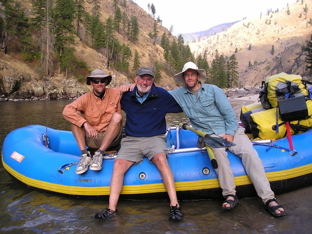
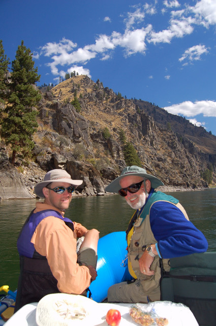
After landing at the small town airstrip and listening to the pilots tell us how “that was an unusual one”, we were greeted by Brian and his road worn red Jeep Cherokee topped with a huge metal raft frame. The Three Fishkateers reunited yet again!
The next morning we crammed everything into dry bags strewn around our motel room, and compressed the Jeep’s suspension with a huge load for the ride down the washboard dirt road dug out of a valley river embankment by the CCC all the way to Corn Creek. There were no more roads for another 80 miles down river through the pleasantly named River of No Return Wilderness. Our mantra had become “Watch your head” as each of us banged our heads repeatedly on the overhanging metal raft equipment above the car, so we were all ready for open air wilderness without any smacks of low clearance overhangs.

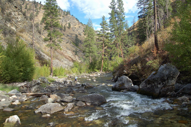
The wilderness and forest before us was vast – taking up about a third of the state of Idaho – and the canyon was deep – second deepest in the continental US and even deeper than the Grand Canyon. Yet it was also full of history.
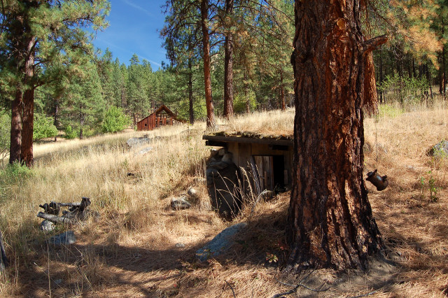
Lewis & Clark explored the beginnings of this part of the Main Salmon River but determined it to be impassable. Since then reclusive trappers came from above and bushwhacked down creek-cut ravines to the enticing beauty and food of the lower canyon. Then an intrepid few survived – and others didn’t – while trying to navigate their way down the tight walls of the Salmon’s river canyon. Although the boats were cumbersome and decidedly low tech, a few men were able to make the run repeatedly to bring in supplies to occasional remote cabins or bring in surveyors for a railroad line that never happened. Some men actually ventured deep into the canyon, found a suitable side spot for food and perhaps mining, and dismantled the wood of their boat to form a simple cabin as uninsulated protection against the elements.
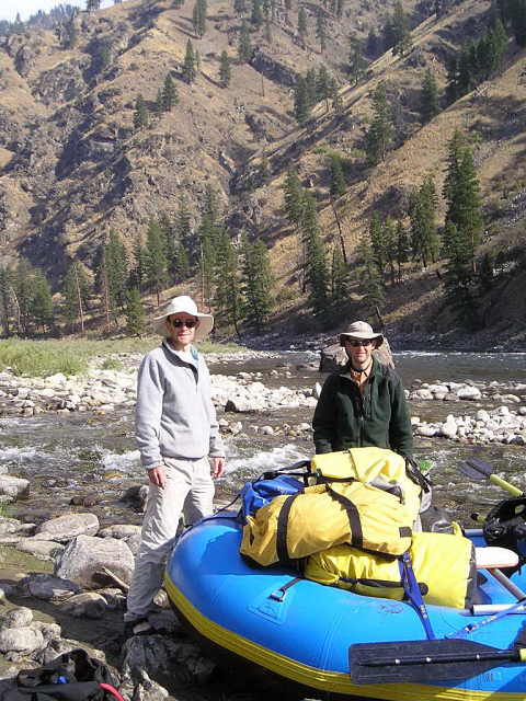
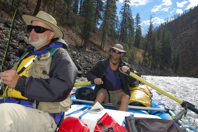
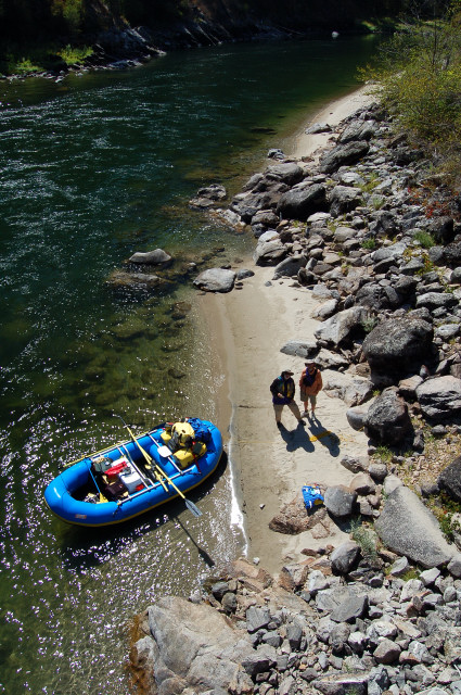
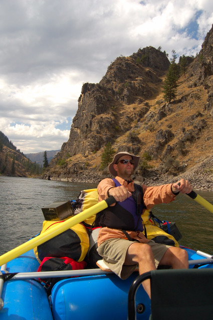
After registering with the ranger at road’s end by Corn Creek, we rigged Brian’s raft for a week on the river. The approach to selecting food for the trip was “it’s a big raft and we ain’t backpacking”, so dry bags and bear-proof canisters were filled with loads of junk food plus a few recommended bricks in the food pyramid, while the cooler was jammed with chocolate milk, Pepsi, Dad’s infamous camouflage patterned cans of Coors (nicknamed “camo 20s”), o.j., yogurt, and some token veggies among the ice blocks. Fold up chairs, individual tents, extra cameras, and other hardware created a mound of large dry bags in the stern, all tied together and secured tightly to the raft in case of a real time accidental white-water swim session.
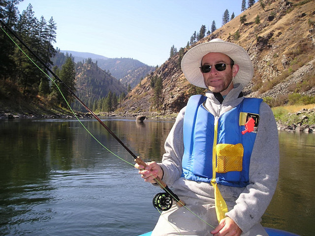
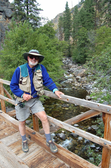
Our fashion statements were synchronized: PFDs, wide brimmed hats, sunblock, waterlogged shoes, and quick drying layers. Fly fishing vests, fly rods, and a bail bucket were all within easy reach. No seat belts on a raft ride, though.
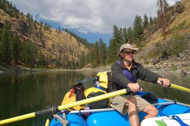
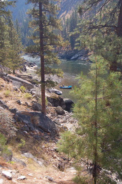
With everyone excited to get started in the River of No Return Wilderness, we launched and the current grabbed hold to take us away from civilization and down river. Brian adroitly manhandled the oars and led us through serene stretches of flat water punctuated by fun white-water rapids. We would generally hear the next rapids before seeing them, as their amplified white noise bounced upriver between the looming canyon walls.
The canyons that have been etched by the Main Salmon River are impressive and stark. All types of rock walls are colored gray black by omnipresent lichen, interspersed by vertical meadows of golden grasses that glow warmly in the sun. Hardy ponderosa pine trees sprout from hillsides, rockslides, and the river banks, yet just as many are blackened poles with their limbs and needles burned away by past forest fires. Walks through the woods can smell like the morning after a big camp fire.
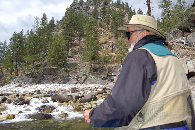
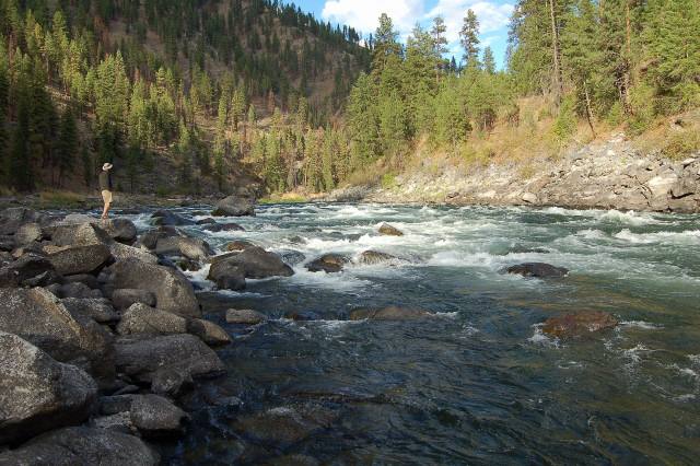
The river runs cold, so hopping off the raft for any reason is rather invigorating, and fishing while standing in the water on the bottom of the raft makes those dry socks back at camp a first priority when setting up camp. Living in those chilly waters are a Noah’s ark full of great sport fish: rainbows, goldens, salmon, bass, herring, and more. Our primary pursuit fish for the week was trout.
Heading downriver, just us and our raft, began the sights and sounds. The countryside is semi-arid, which is why the grasses do well amidst the sporadic ponderosa pines and douglas firs when they are not serving as perfect kindling. The rush of the waves, plunk of the oars, and creaking rigging all mix with the melodies and fluttering wings of mergansers, dippers, kingfishers, osprey, and golden eagles.
Our first day on the river took us through Killum Rapid, Gunbarrel Rapid, Stub Creek Rapid, and smaller unnamed rapids that sped us along. 6.1 miles downriver from Corn Creek we pulled onto the shore at Spindle Creek.
The flat sand and rock bar of the site served as the location for Colin Lovelock’s cabin in the 1950s. A flourishing apple tree and the base of a stone wall reminded us of his presence. The apples tasted good, too!
The next day we continued onward. Dad already caught the first fish of the trip, and I caught the first rainbow trout. Our biggest catches were the raft itself and immovable “rockfish”. We usually fished from the bow of the raft, feet down in a cold puddle with our knees braced against the forward tube. One fish got loose in a squirmfest on the bottom of the boat, but eventually was smart enough to flip itself into a net so it could be returned to the river.
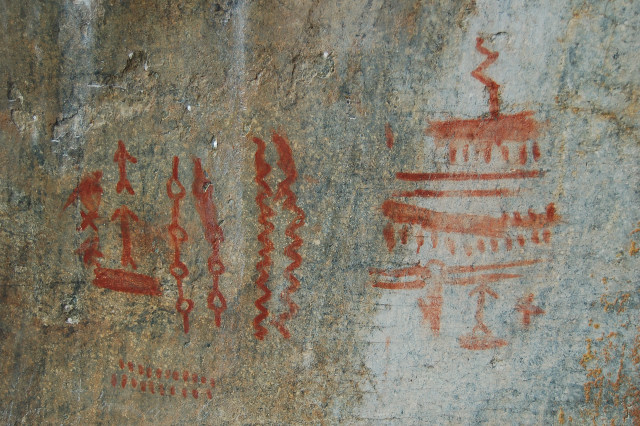
We headed through Rainier Rapid, Lantz Rapid, and Devils Teeth Rapid, passing by several pretty creeks that cascaded over river-smoothed rocks into the Main Salmon. An interesting stop along the way is Devils Toe pictographs, one of many pictograph sites remaining untouched in the canyon.
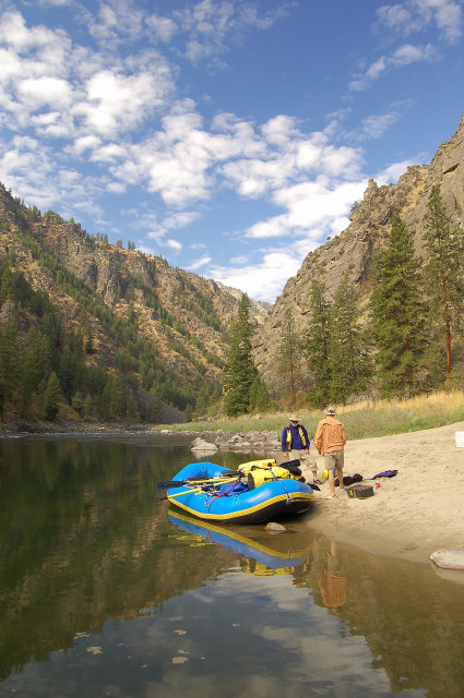
That afternoon we landed at the beach above Chamberlain Creek, finding a beautiful campsite that overlooked both the large flowing creek and the Main Salmon. We cooked up some good food from our floating grocery store. A can of tiny shrimp added to alfredo noodles is highly recommended, by the way. Morning breakfast was classic oatmeal packets.
A heavily overgrown trail follows Chamberlain Creek for 18 miles out to a remote ranch, and it makes for some pretty hiking in the woods even though much of it is charred from wildfires and there are many fallen trees to jump over along the trail. Dad and Brian found some productive fishing holes along the way.

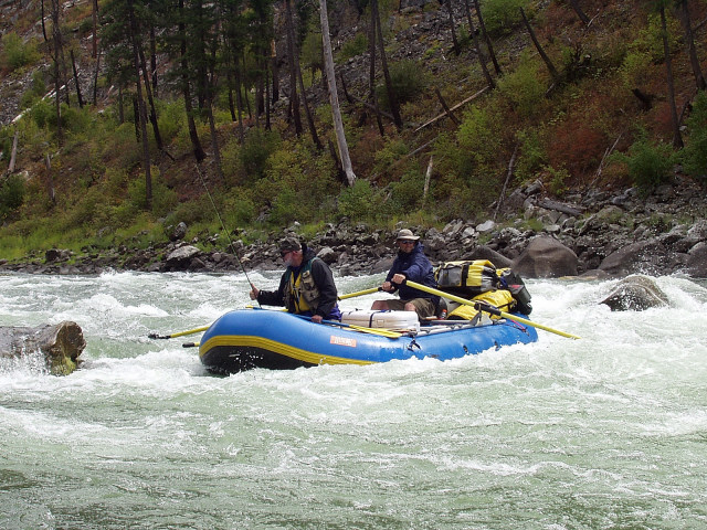
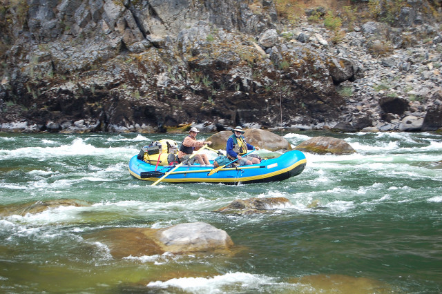
Day 3, the river took us through Little Devils Teeth Rapid and Salmon Falls, which was the most technical rapid of the trip so far and required Brian to maneuver us through a small slot and down a small waterfall between huge raft-flipping boulders. Floating along, we passed the sites and derelict motors of placer miners who in the past would boat in old truck motors, fuel, and parts. The men then proceeded to “mine” by blasting away the hillside and river bank with powerful water hoses, usually looking for gold. It must have made a mess of the river when it was done; I wouldn’t recommend trying to get a permit for that technique nowadays.
We also saw a few more raft and kayak groups on the river, all of which were friendly and shared a sense of camaraderie in place and purpose. A couple jet boats also cruised by, which are propellerless low draft boats that are grandfathered in since a few outfitters used them as motorized access up and down the Salmon before the entire area was officially designated wilderness.

At mile 24.8, we pulled up onto the shallow rocks at Bruin Camp, setting up our tents on a pretty and level expanse of sand above the river. Dad was able to catch some beautiful goldens from the river bank in front of camp, using both dry flies and nymphs. The next morning I walked past the fresh night-visit deer tracks around my tent and wrote by the river’s edge as the sun rose over the valley walls and warmed me.
The canyon’s hillsides have a different appearance whether you are looking to river left or river right. The Main Salmon flows consistently and directly from east to west. So river right, or the north shore, is facing south and therefore gets dried out by direct sun. River left is usually in shade, and retains more moisture. The result is more sporadic ponderosa pines and open expanses of grasses on river right / north side, with somewhat denser stands of douglas fir on river left / south side.
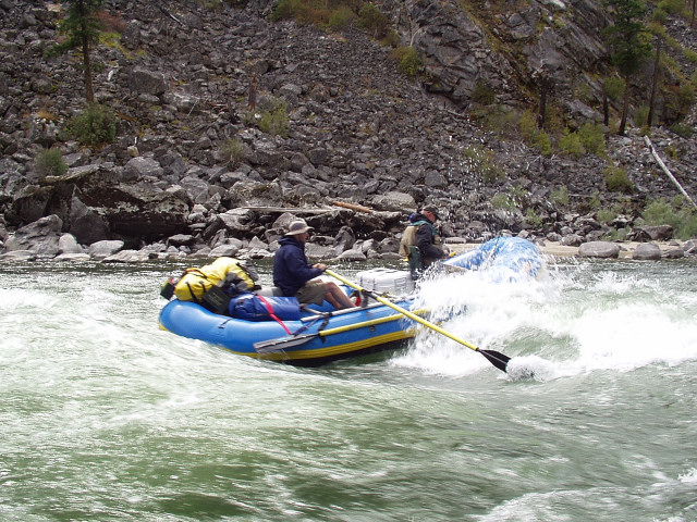
On Day 4 the intensity level of the rapids was ratcheted up a notch, and we did scout ahead on several of the more major white-water sections. After Hancock Rapid, we ran more technical stretches such as Bailey Rapids, Five Mile Rapids, and Split Rock Rapids. In Brian’s words, he nearly “tore his shoulder off” powering us out of a hole (where water falls over a rock and creates a backwards hydraulic action that can spin and flip a raft if not properly handled). Many fun little unnamed rapids also pushed us along throughout the day.
This stretch of the Salmon actually has about 4 or 5 cabins on it, throwbacks to the days before wilderness designation. Most are nicely kept up, some have caretakers, and one is part of a large ranch where the owners invite Christian missionaries to stay in a place of beauty for personal introspection.
After 12 miles on the river, we rested for the evening at Upper Yellowpine campsite. Beautiful! Spacious flat site with rocks for natural tables, all looking out over an expanse of private river, fronted by trees and backed by an impressive high dark rock cliff wall. We enjoyed our time there: talking, fishing from the shore (with an apparent contest to see who could hook the smallest fish), and fixing up some good camp grub. Brian and I took a short hike down river to pre-scout tomorrow’s first big rapids, hopping rocks and enjoying all the different vantage points along the way. And before sleeping soundly in my tent I was treated to a bright moon rising through the trees lining the upper reaches of the opposite canyon wall, illuminating our campsite and softening the otherwise vibrant star night sky.
The next day started immediately with a wild ride through Big Mallard Rapids. We had one plan, the river had another, and we got whisked along on a great little sprint. Other rapids were scouted in advance, too. We all took turns at the oars, with Brian at the helm for the big stuff. Little Mallard Rapids, Elkhorn Rapids, Growler Rapids, Don’t Lose Me Now Rapids, Whiplash Rapids, and others greeted us today and gave us a bail bucket session or two.
As we’ve rafted deeper into the canyon, I’ve grown increasingly intrigued by the characters who have actually built their lives in the deep recesses of the canyon over the past 100+ years. Some were married with families, some were on the run from the law, others were lone trappers or miners or self sufficient farmers, and others just wanted to get away from the rest of the world and move to a place where nowadays people only visit for vacations.
We pulled ashore at a suspension bridge built at Campbell’s Ferry, where an enterprising settler used to run a river crossing service for miners trying to unearth their fortunes, prior to the construction of the bridge. The dilapidated, but still standing, remnants of Francis Zaunmiller Wisner’s homestead are located on a moderate open slope above the south side of the bridge. Francis was a telephone operator in Texas who decided to ditch her past life and create a new one somewhere north. In 1940 she ended up as one of the few who lived on the river, and built a small homestead with each of her two husbands (both of which were local river men; presumably because they were among the very few available men around?). On the other side of the river from her cabin, I walked around the sunny unkempt grass fields of Jim Moore’s old farm, wandering among the two cabins, barn, rusting farm machinery, icehouse, and junk still laying around. It must have been quite the lifestyle, both independent and solitary.
As a solid reminder that these were not the true initial settlers, though, elsewhere on a river bank we found another well preserved set of native American pictographs.
Paine Creek Camp was about right for stopping point distance for the day, so we pulled in and were pleased to find yet another great campsite. Tucked away under a few trees within the folds of a rock cliff, it gave Dad another good spot to ensure that he was not “skunked” by being fishless on any day of the trip. My scratchy scalp was clamoring for a camp shampoo, so I dunked myself partly in the cold river and used a soapless washcloth to clean off the day’s (and week’s) grime before washing my hair up in the woods (so that any soap residue would get filtered prior to entering the river). All day long we saw hardly any other folks, so I cleaned up at the water’s edge buck naked. Of course that was exactly when I happened to notice 6 people on three rafts right in front if me, all staring at my riverside peep show.
We deliberately planned to raft the Main Salmon at this early/mid September time frame since this was the time period when no reservations were required and it’s all first come first served. During the high summer season, planning and camping can be a conflicting chore among both private and commercial boat groups. But this time of year the lack of people is very peaceful, and finding unoccupied campsites has been consistently easy in getting our first pick priority sites. The water levels are also much lower, which generally makes most rapids more accessible and first-rime-runnable for private parties new to the river, such as us.
The next day opened cool, with smooth blue skies floating cotton ball clouds, as every morning on the trip has greeted us. The days warm and clear as they progress, and the evening slowly returns to cool after the sun disappears behind the towering canyon walls while we cook dinner by the low whooshing sound of our camp stove. It only rained three times: once just as we we were getting ready to unload at Corn Creek, which we waited out in the Jeep for twenty minutes before the sun rejoined us. The second time was a sprinkled drizzle in the middle of the night, just enough to dampen the dry ground. And the third time occurred as we were packing our raft into the Jeep on the way out. So, we were never really rained on at all during our time on the river.
While on the river, we wear several layers of clothes to ward off the chill from the air and the cold river. Canyon wall shadows – and standing in river water on the bottom of the raft – can cause big temperature swings compared to later rounding a corner to absorb full sun again. Of course, whoever is manhandling the oars is generating more heat than the others sitting up front in their splash-soaked pants. I usually announced each day when I got my first crotch soaking, which also meant my underwear was wet from there on out for the rest of the day.
Except for a couple big rapids, the river mellowed out considerably. Early on, we barreled through Boise Bar Rapids, Action Jackson Rapids, and Ludwig Rapids for some good rides and great boat handling by Brian.
Around the confluence with the South Fork of the Salmon River, the character of the river changes considerably. Guides call this section of the river “Salmon Lake” since it is mostly placid slow moving water, reflecting the scenery upside down on its surface. But, more importantly, the scenery becomes even more interesting and varied. The canyon walls tower above seemingly higher and closer than before, leaving the grass and forests behind for impressive spiky rock formations looming far overhead. Cliffs continue their gray black lichen-covered appearance, but appear more fortress-like in their solidity and huge scale.

Interjected among the beauty is also more human development, though it is still rare and sporadic, plus frequently comes with terrific gossipy history.
We passed the rock gun tower built by mountain man Buckskin Bill; the Forest Service said he was squatting and he was prepared to defend his land (it turned out neither Buckskin Bill nor the Forest Service owned the land, but instead it was owned separately as part of a private mining claim). We also oared by Polly Bemis’ ranch; she was sold into an underground Chinese slave market as a child, but her freedom was negotiated by the man she later married, and they enjoyed the remainder of their lives on the shores of the Salmon. We even passed a couple very small outdoors-oriented guest lodges and an incongruous little “store” in an outfitter’s cabin accessed by the river beach; this was permitted since we passed through the boundary of the official wilderness designated land on the north shore. The south shore was still designated wilderness land all the way out, and there was generally no way to tell the difference since it remained almost entirely remote, un-built, and inaccessible to vehicles. And even the wilderness areas still contain sporadic small privately owned tracts with grandfathered uses.
Alex Meadows was the setting for another peaceful and utterly private camp site. We passed a few people on the shore, but we did not come upon a single boat that day on the river; the solitude has relaxed all of us. In camp, we fished from the shore in front of our tents and were visited by 12 bighorn sheep. After a lot of rowing, some headwinds, and flat water’s slower currents, we continued our progressively earlier downward adjustment of bedtime. Our sleep cycles were adjusting to be river farmers.
Then, as usually happens for people with jobs, family, and other lives, the last day of this trip brightened through our tents. Some good fun rapids roared ahead of us, and there were fish out there to be caught.
Fishing had been very consistent throughout the week. Casting a line from the raft or shore during the day was usually just an exercise in practice of casting technique. But in the later evening, fish would get hungry for the insects we saw flying around, and then we started hauling a few in. Some were small enough that their downward size was probably limited by the fish mouth’s ability to just get around the hook. Dad consistently won the award for largest fish catches, once from a good eddy at a rock tumble outcropping below rapids. The other big catch of the week was at the mouth of a stream while straddling the raft.
Sheep Creek beckoned for a pleasant and pretty side canyon hike up into the hills a ways. Warmer stream water flowed over rocks, around fallen trees, and into natural green circulating pools that all eventually spilled across a boulder field into the Main Salmon.
The fun rapids continued to be interspersed with stretches of slow moving flat water, and the winds tried to push our non-aerodynamic boat back up river, giving Brian quite a workout at the oars. Dad began renaming all of the rapids, mostly with an R-rated flavor for his own future spicy river guide book.
Immediately down river from Chittam Rapids, we got off the river at the Vinegar Creek boat ramp. This started another washboard dirt road on out, fulfilling the loop we created when we drove to Corn Creek a week ago and connected these roads by almost 80 miles of wilderness river in between.
We all got what we asked for, and much more: Guys goofing around together in beautiful scenery on a unique and interesting wilderness river, with no boat flips, too much food, and another great outdoors reunion of The Three Fishkateers!