A smooth white table top cloud bank curved gradually to the horizon in all directions. Uniform surface temperatures on the Pacific Ocean created this phenomenon on a cloudy day, looking like a drive across snow covered Kansas plains from above. But we weren’t in Kansas anymore, Toto.
Chile was a nexus for junkies of the great outdoors. 2800 miles long and at most 110 miles wide, it offered exactly the stage that backpacking performers everywhere seek: bounded by looming Andes Mountains to the east and rugged Pacific coastline to the west, filled in with everything from deserts north and glaciers south. It was a nationwide jungle gym.
Practically all international flights arrived in Santiago, where a third of the entire long and thin country lived. Arcing over the Pacific and across valleys of deep green farm fields, arrival was a full two time zones east of the US east coast. And after 18+ hours on planes, we were ready to play.
Through the gauntlet of come-ride-my-taxi men, and lopsidedly lugging a heavy backpack whose shoulder strap had just ripped off, we made our way into Santiago’s excellent public transit system by bus, subway, and then shoes. As happens in trekking corners of the world, ridermates across the aisle were from our old stomping grounds of Portland Oregon, demonstrating yet again how big and small the world really was. After dumping our gear at a hotel, we went out exploring the city.
Santiagans were consistently friendly, especially so with each other. The lush urban garden park Cerro Santa Lucia was full of lovers rolling in the grass, smooching and groping. No taboo on PDA here. It was easy to understand why Lover’s Lane in Santiago was destined to be this park: serpentine hand-in-hand walking paths winding through overhanging century old trees, leading through romantic brick gates and up to the top of a hill for a 360 degree panorama of the city. There were many private nooks and crannies, topped by the sunset-watching perch that encouraged pointing out in the distance at what you know and wondering at what you didn’t.
For an even wider range of people watching beyond lovers and families, we went to the 450 year old Plaza de Armas. It was both the literal and figurative center of the city, and had constantly entertained ever since its creation. Surrounded by imposing ornate brick buildings that were once the Metropolitan Cathedral, Governor’s Palace, and Royal Court of Justice, it provided both stage and seats for the citizens of Santiago. Business people and families sat shoulder to shoulder on benches with homeless folks a touch loco in the head and artists creating or hawking. Peddlers peddled, singers sang, preachers preached, and a bedraggled Santa wanted you to a take a picture with him. Food that fell from the corners of mouths fed pigeons, water splashed from the fountain by wading children flowed to puddles that quenched feral dogs, and trees shaded the watchers and the watched below. It was a complete concrete ecosystem.
An evening walk beckoned through the city’s better neighborhoods of Bellavista and the Parque (park) Forestal. Bellavista’s café tables spilled out onto the sidewalk as locals gathered socially over coffee and pastries. Within sight, a sprawling tree-lined park bordered the muddy brown Rio Mapocho, holding thousands of children on playsets, seniors walking dogs, families with picnics, and yet more lovers lip wrestling.
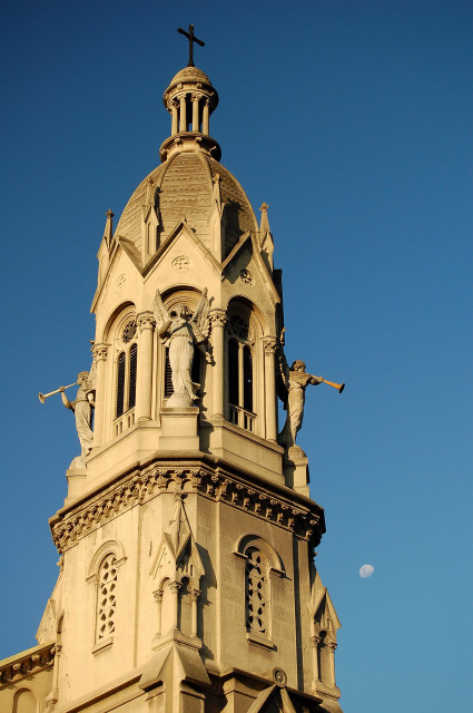
Santiago’s Capilla Liceo Alamen
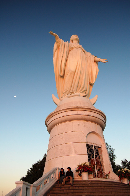
Virgen de la Immaculada overlooking all of Santiago from the top of Cerro San Cristobal
Chile then introduced us to its length, by way of the usually needed mix of transport: Santiago to Puerto Montt and Punta Arenas by airplane, Punta Arenas to Puerto Natales by bus, then by madcap taxi ride searching for an available accommodation (we passed on the room in a lady’s house with the dirty spongy U-shaped bed), and then by foot for getting our bearings and to dinner.
The plane ride from Santiago to Punta Arenas could be spectacular if the highly variable weather was right, which it was. The flight was at a well tuned height: high enough to get a great sense of scale, yet not so high as to make details difficult to see. Snow covered conical volcanoes of the Lake District projected upwards from the green forests and farmland below, as if they were one of the crops on a massive scale. Meandering rivers etched valley floors as they provided sustaining water until emptying into the Pacific. We even saw the Torres (towers) del Paine themselves, the famous rock towers that we would trek to in a few days. One man on our trek said he had done that flight 20 times and only saw the Towers once because of the usual cloud cover.
After hauling our backpack-filled duffel bags to the Punta Arenas “bus terminal” (basically a small garage with a waiting area), we left that simple town and rode across windswept rolling hills. With the ocean on our right and flocks of grazing sheep on our left, it was a steady three hour trip only occasionally punctuated by a farmer joining us from the side of the road.
Puerto Natales suddenly appeared from over a rise, unusual after three hours of the pasture hills. It was a small town, mostly filled with simple buildings of metal roofs and low design to protect them from 100 mile per hour gusts. Situated on the low hillside of Senoret Canal between Seno Ultima Esperanza (Last Hope Sound) and the Almirante Montt Gulf, it was apparent the place was born of its waterfront and had capitalized on that location with an oil refinery, ferry service, and fishing. However, its tide was changing toward tourism, given its prime location as the last outpost before entering Parque Nacional Torres del Paine or Parque Nacional Bernardo O’Higgins. The original businesses supporting the locals were still there, but they were slowly being outnumbered by outfitters, lodging, and Internet cafes. I’m glad the originals were still around since a shoemaker fixed my broken backpack.
By bus the next day we rode another two hours into Torres del Paine Park, passing skittish llama-like guanacos through the scrub brush hilly valleys. Next we were onto a van filled with the many chattering languages of trekkers, and we were finally delivered to road’s end.
Over the next eight days we experienced the many natural wonders of Torres del Paine, accentuated by the terrific commingling of cultures that always happens at the world’s best trekking destinations. The park was an unusual and somewhat disconcerting mix between a sense of untouched natural beauty always within a few hours walk of a safe bed with fireplace and hot prepared meals. The convenience was great, though it diminished the sense of remoteness in getting away. Any difficulties or challenges were served up by very steep trails and off-trail exploring, not from any sense of being too far from civilization. There was no search and rescue or much infrastructure, yet you were usually fairly close to other trekkers and the occasional refugio (dorm style mountain cabin). A professional guide later explained to me that the refugios within the park were one way to concentrate people and minimize the environmental impacts of widely spaced camp sites in the delicate local ecosystem, so there were benefits beyond the convenience of the privately owned and run refugios.
We decided to do the “W”, which was a 5 day route of north-south, west, north-south, west, and north or north-south again, creating a semi-W shape. This was the most special route in Patagonia Chile since it touched on some of the continent’s most beautifully grand scaled locations.
At road’s end it felt like a herd of jabbering trekkers. Besides the refugio was a huge hotel with spa, and Gore-tex was everywhere. Our Refugio Torres reservations were nowhere to be found by the refugio staff, all the rental tents were rented, the hotel was full, and we were a 2.5 hour drive back to Puerto Natales plus would need to figure out how it would even be possible to get a ride back there in the first place. Instead, we decided to immediately set out for our second refugio, Refugio Chileno, which was up Valle Ascencio towards the actual Torres del Paine. The refugios radioed back and forth, and we were in for a reservation. Although it was past 7:00 at night before starting out, and it was a steep hike, we relied on the long summer days to get us up there, which they did.
Refugio Chileno ended up being much better than Refugio Torres anyhow: set aside a glacier river and accessed by a rickety footbridge, its location was more idyllic and the number of people more pleasant. It had hot showers, hot meals, 8 bunk beds per room, and even some cookies. We were also closer to our next day’s destination, the Torres, and so could be more leisurely paced in getting there.
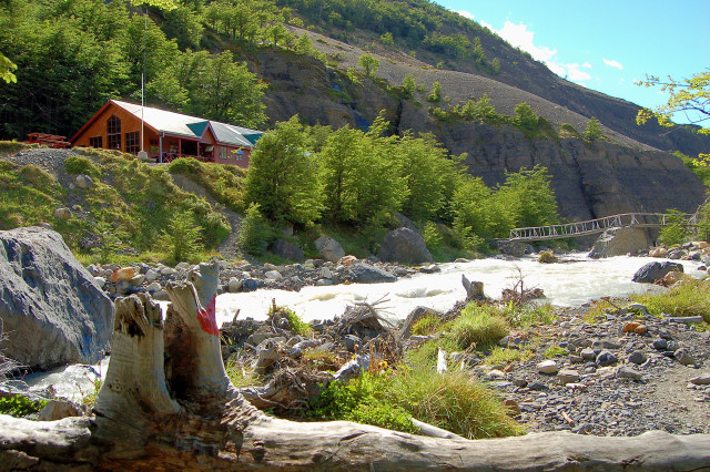
Refugio Chileno by the Rio Ascencio in Torres del Paine
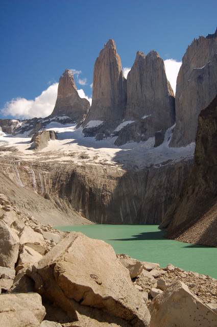
The Torres were reached by a steady upward trail followed by a cartilage grinding long boulder field ascent. Coming to the top, the three 9000 foot tall spires quickly came into view. Unexpectedly, they loomed over a glacial flour lake and the vista broadened out for the grand view of so many books and postcards.
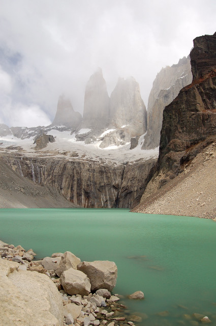
The Torres del Paine
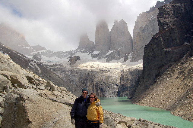
The three towers were impressive examples of geology’s power in upwelling, erosion, and leaving behind lasting art. Aside from their massiveness and the seeming impossibility of their sheer walls jutting thousands of feet straight up, I especially enjoyed their play of light and weather. The towers formed their own clouds, and this everchanging dance tangoed with the Sun as its light brought new accent shadows and facial expressions throughout hours of watching them. One felt they were watching back.
Hiking again above the Rio (river) Ascencio, we took the shortcut westward to Refugio Cuernos (which was not marked on most maps). The glacier fed gray brown river cut through wet black volcanic valleys, while clear sparkling streams from snowpack on the mountains above bounced over rock and moss on its way to the gorgeous Lago (lake) Nordenskjold. Short wind-battered hardy trees lived in protective clumps among the Patagonian steppe grasses, filled with the songs of a surprisingly large variety of birds. Glowing flowers stood out among the green background matte: red fireworks of the Ciruelillo, yellow shoes of the Zapatito de la Virgen, purple to pink berry balls, yellow white starbursts, and so much more. Some sections of trail had the ambiance of a planned garden.
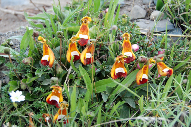
Zapatito de la Virgen
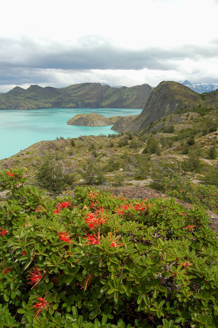
Gray, almost threatening, clouds crowned the mountains and created portholes of sunlight moving across the valleys. Light rain sprinkles, sun, light sprinkles, wind gust, sun. The views opened up to aquamarine Lago Nordenskjold below, and we traversed up and down along its north shoreline.
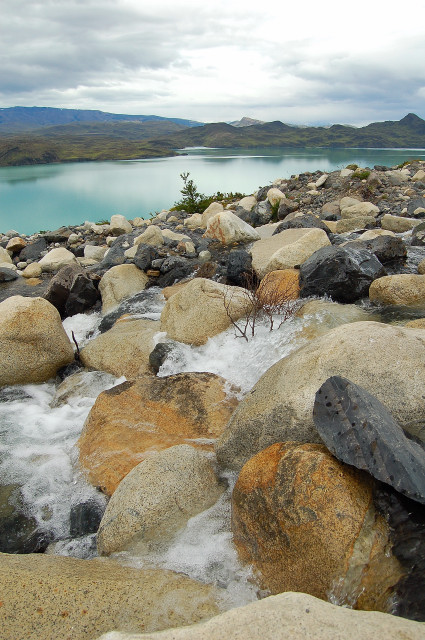
Snowpack-melt river cascading down to Lago Nordenskjold
Ciruelillo flowers above Lago Nordenskjold
Above to our right, the black rock canyons were interlaced stark white with small V cuts of waterfalls billowing downwards. Landslides and rock piles were everywhere, triggered by cutting glacial rivers undermining steep slopes above. The evidence of young mountains in action, the aftermath of a twelve million year old laccolith upwelling.
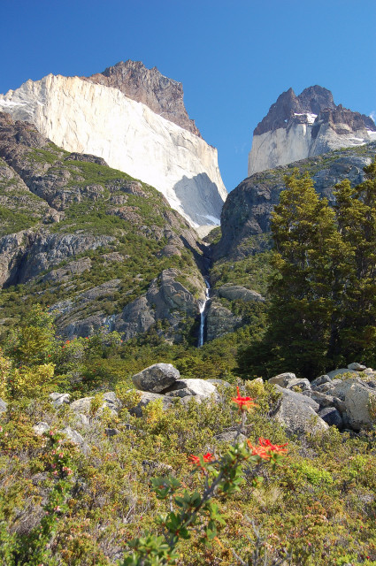
Waterfall draining from between Los Cuernos
Refugio Cuernos was set on the shores of Lago Nordenskjold, below the imposing Los Cuernos (The Horns). This time we tried renting a tent, bag, and pad for sleeping outside instead of using the bunks inside. But we still revolved our activities around the international melting pot in the communal dining area that was a highlight of every refugio.
The feeling of goodwill and mutual interest at the trekker hangouts was heartwarming. As was the case around the world, most trekkers were from Australia, Canada, Germany, UK, France, and a sprinkle of other European countries, though here there were of course many from throughout South America and certainly the random mix of surprise countries. The long family style dining tables and close quarters made it so easy to start conversations with complete strangers, and fortunately English was one of the foremost universal languages of travel.
Certain characters would come in and out of our environs, while with others we would reunite evening after evening if we sometimes moved in the same trail direction and to the same refugios. There was the three month pregnant Dutch couple, the 65 & 70 year old ex-hippy British couple taking an easier part of the route and spending some of the proceeds from the sale of their rental property, three Irish women recently out of college, the Scottish politician’s assistant, the Idaho couple originally from Germany and Columbia who drank lots of wine and told lots of stories, and so many more. We all shared life vignettes, and also learned about people’s experiences in their own countries. Terrific, relaxed, open, funny conversations.
On the shores of Lago Nordenskjold
Along the shores of Lago Nordenskjold we walked head into the blustery Patagonian winds below cool refreshing blue skies. The cavalcade of plants continued at our sides: low evergreen bushes, mounded humps of prickles, grasses, ferns, and decaying fallen tree trunks. Most of the trees in the park were short and young, yet the area was once a deep cold forest. Over 100 years ago Chilean companies turned their attention to sheep and wool in huge numbers, and this then unwanted land was cheap and conducive to profitable wool business. Much of this part of Patagonia was deliberately burned to a crisp, opening up lands for grassy pasture while destroying an entire ecosystem. If it ever recovers, it will be many centuries from now.
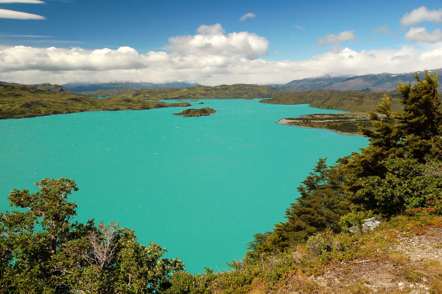
Yes, that is the real color of Lago Nordenskjold’s glacial flour waters